







PDS Severe Thunderstorm Watch issued in central US as storms erupt
FOX Weather Meteorologist Nick Kosir outlines the potential for dangerous storms in the Plains on Sunday.
The central U.S. is bracing for what could be a potentially dangerous end to the weekend as forecasters track the threat of severe weather on Sunday, including the potential for a derecho that could sweep across portions of Kansas and Oklahoma with destructive wind gusts higher than 100 mph and baseball-sized hail.
This comes on the heels of another deadly derecho that barreled across Texas and Louisiana on Thursday, blasting the Houston metro area with winds up to 100 mph that left at least seven people dead and more than 1 million customers without power.
HOUSTON RESTAURANT OWNERS SCRAMBLE TO GET PATRONS TO SAFETY AMID BLISTERING DERECHO: ‘IT WAS HORRIBLE’
Tornado, Severe Thunderstorm and Flash Flood warnings have been issued across several states Sunday.
Severe Thunderstorm Watches were issued Sunday afternoon for several states in the central U.S. from South Dakota to Texas. The watch that covers parts of Kansas, Oklahoma and Texas was designated a “Particularly Dangerous Situation” by NOAA’s Storm Prediction Center, emphasizing the dire nature of the storms that are forecast to develop in that area.
HOW TO WATCH FOX WEATHER
The National Weather Service has already received eight reports of tornadoes across Colorado and Kansas on Sunday, with one believed to have crossed Interstate 70 west of Russell, Kansas.
Hail between tennis ball- and baseball-sized has also been reported with several storms. The largest report to the NWS as of Sunday evening was 3-inch hail in Ellis, Kansas.
Watch: Hail pounds Kansas
Hail came down fast and furious during a thunderstorm in Salina, Kansas. The largest stones were marble to quarter-sized.
Wind that has damaged trees and powerlines has also been reported with the storms. A wind gust of 100 mph was reported at the airport in Salina, Kansas, on Sunday evening. A gust of 90 mph was reported near Fowler, Kansas.
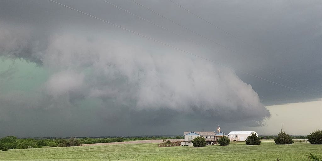
The shelf cloud of a supercell is seen approaching Salina, Kansas, on May 19, 2024. (MikeH_SA119/X / FOX Weather)
Sunday marks the beginning of a multiday, multistate severe weather threat that is expected to impact millions of people from the Plains to the Midwest through at least Tuesday, although the threat of severe weather will continue in the central U.S. through at least the middle of this upcoming workweek.
NOAA’s Storm Prediction Center (SPC) increased the severe weather threat on Sunday and is focusing on central Kansas, where the threat of destructive wind gusts and large hail is highest.
The threat will expand to the east Monday and Tuesday, putting tens of millions of people in the Plains and Midwest at risk of seeing extreme weather.
DOWNLOAD THE FREE FOX WEATHER APP
Potential derecho could blast central US today
The SPC said severe thunderstorms are expected to fire up across portions of Kansas and Oklahoma starting in the late afternoon and lasting into the evening hours, which includes the potential for a derecho.
“Destructive wind swaths of 80-100 mph may occur, with localized extreme wind gusts exceeding 100 mph possible,” the SPC said in its forecast discussion. “Very large hail and a few tornadoes are also anticipated.”
Because of the threat, the SPC placed nearly 570,000 people in Kansas in a Level 4 out of 5 risk on its 5-point severe thunderstorm risk scale.
WATCH VS. WARNING: HERE ARE THE DIFFERENCES BETWEEN THESE WEATHER TERMS THAT COULD SAVE YOUR LIFE
This graphic shows the definition of a derecho. (FOX Weather)
This includes Dodge City, Great Bend, Salina and areas just to the north of Wichita.
The severe weather threat isn’t limited to those areas, however.
The SPC also placed about 850,000 people in Kansas and portions of northwestern Oklahoma in a Level 3 out of 5 risk.
This threat includes Topeka, Wichita and Hays in Kansas, as well as Woodward in Oklahoma.
Life-threatening lightning, tornadoes, damaging wind gusts and large hail will all be possible from any severe thunderstorms that develop in the region on Sunday.
And while there is a tornado threat across portions of Kansas, Oklahoma and Nebraska, forecasters said they’re much more concerned for the threat of destructive wind gusts and baseball-sized hail.
The SPC said there is a higher risk on Sunday for the development of supercell thunderstorms that could form into a bow echo as they sweep across the region.
“Now, we’ll watch for the damaging winds,” FOX Weather Meteorologist Craig Herrera said. “And when we’re talking damaging winds, you’re talking wind gusts 75 mph or greater. You think of sustained winds from a hurricane are 74 mph. These are gusts, but a gust that quick and that fast at 75 mph or greater can still do some damage.”
And some of these thunderstorms on Sunday could produce wind gusts as strong as a Category 2 hurricane.
The SPC said there could be swaths of 80-100 mph wind gusts, with localized areas reaching gusts higher than 100 mph.
Monday’s severe weather threat
There are now two areas of concern for severe weather on Monday.
The SPC has placed just over 17 million people in a Level 2 out of 5 risk, which includes portions of Colorado, Nebraska, Kansas, Missouri and Iowa, as well as portions of Illinois, Indiana and Wisconsin in the Midwest.
The cities of Norfolk, Omaha, Lincoln and McCook in Nebraska are all included in the risk, while Des Moines in Iowa is just outside that Level 2 threat.
Kansas City in Missouri is also included in the Level 2 threat on Monday.
Milwaukee and Chicago have also been placed in a Level 2 out of 5 risk on Monday.
Thunderstorms that develop in the Plains and Midwest will all be capable of producing damaging wind gusts, hail and possible tornadoes.
Tuesday’s severe weather threat
The SPC issued a Level 3 out of 5 risk for severe weather on Tuesday, which includes more than 9.5 million people.
This threat will have people in seven states from the Plains to the Midwest on alert for storms capable of producing damaging wind gusts, hail and possible tornadoes.
And while those areas will see a greater severe thunderstorm threat on Tuesday, more than 31.5 million people in areas stretching from Oklahoma to Michigan have been placed in a Level 2 out of 5 risk.
This Level 2 risk includes the cities of Oklahoma City and Tulsa in Oklahoma, St. Louis in Missouri, Chicago in Illinois, Minneapolis in Minnesota and Milwaukee and Green Bay in Wisconsin.
Credit: Source link