






• bitcoinBitcoin(BTC)$78,758.00-0.02%
  • ethereumEthereum(ETH)$2,496.260.01%
  • tetherTether(USDT)$1.000.01%
  • binancecoinBNB(BNB)$740.38-2.03%
  • rippleXRP(XRP)$1.42-0.93%
  • usd-coinUSDC(USDC)$1.000.00%
  • solanaSolana(SOL)$103.34-0.81%
  • tronTRON(TRX)$0.3404730.25%
  • Figure HelocFigure Heloc(FIGR_HELOC)$1.02-2.49%
  • zcashZcash(ZEC)$1,282.597.80%
  • HyperliquidHyperliquid(HYPE)$85.451.41%
  • dogecoinDogecoin(DOGE)$0.089187-1.48%
  • RainRain(RAIN)$0.016317-2.40%
  • USDSUSDS(USDS)$1.000.00%
  • whitebitWhiteBIT Coin(WBT)$81.40-0.45%
  • moneroMonero(XMR)$508.311.19%
  • chainlinkChainlink(LINK)$12.03-5.56%
  • leo-tokenLEO Token(LEO)$9.18-0.23%
  • cardanoCardano(ADA)$0.217849-4.17%
  • stellarStellar(XLM)$0.185026-3.51%
  • bitcoin-cashBitcoin Cash(BCH)$258.77-0.08%
  • daiDai(DAI)$1.000.00%
  • Ethena USDeEthena USDe(USDE)$1.00-0.01%
  • USD1USD1(USD1)$1.00-0.02%
  • litecoinLitecoin(LTC)$54.15-0.62%
  • CantonCanton(CC)$0.104215-2.42%
  • uniswapUniswap(UNI)$6.57-4.13%
  • the-open-networkGram (prev. Toncoin)(GRAM)$1.39-1.35%
  • hedera-hashgraphHedera(HBAR)$0.078553-2.21%
  • avalanche-2Avalanche(AVAX)$7.95-0.96%
  • nearNEAR Protocol(NEAR)$2.608.92%
  • Global DollarGlobal Dollar(USDG)$1.000.00%
  • suiSui(SUI)$0.80-3.83%
  • shiba-inuShiba Inu(SHIB)$0.000005-1.58%
  • crypto-com-chainCronos(CRO)$0.059639-0.87%
  • paypal-usdPayPal USD(PYUSD)$1.000.00%
  • BlackRock USD Institutional Digital Liquidity FundBlackRock USD Institutional Digital Liquidity Fund(BUIDL)$1.000.00%
  • tether-goldTether Gold(XAUT)$4,403.550.25%
  • MemeCoreMemeCore(M)$1.17-2.14%
  • Circle USYCCircle USYC(USYC)$1.140.01%
  • BittensorBittensor(TAO)$258.25-3.23%
  • Ripple USDRipple USD(RLUSD)$1.000.00%
  • okbOKB(OKB)$113.37-1.01%
  • Ondo US Dollar YieldOndo US Dollar Yield(USDY)$1.14-0.01%
  • mantleMantle(MNT)$0.62-2.16%
  • aaveAave(AAVE)$129.52-0.42%
  • AsterAster(ASTER)$0.74-3.14%
  • Pump.funPump.fun(PUMP)$0.0047859.07%
  • polkadotPolkadot(DOT)$1.13-4.88%
  • pax-goldPAX Gold(PAXG)$4,407.640.30%
TradePoint.io
  • Main
  • AI & Technology
  • Stock Charts
  • Market & News
  • Business
  • Finance Tips
  • Trade Tube
  • Blog
  • Shop
No Result
View All Result
TradePoint.io
No Result
View All Result

Hurricanes Tammy and Norma to strike Leeward Islands, Mexico this weekend

October 21, 2023
in Market & News
Reading Time: 5 mins read
A A
Hurricanes Tammy and Norma to strike Leeward Islands, Mexico this weekend
ShareShareShareShareShare


CNN
 — 

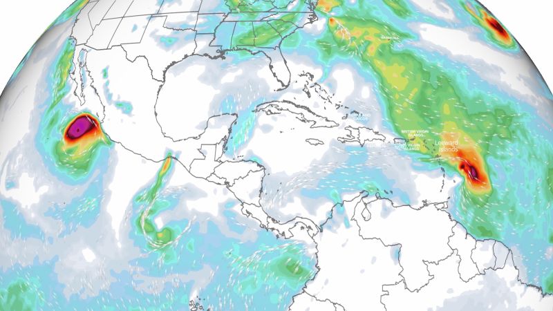
Two hurricanes will strike land this weekend by two different ocean basins – Tammy in the Atlantic and Norma in the eastern Pacific.

YOU MAY ALSO LIKE

Missouri Supreme Court Sets Contempt Hearing in Fight Over House Map – The New York Times

Alamos Gold: The Mine That Broke Isn’t The One That Matters (NYSE:AGI)

Neither are a threat to the US, but Norma has triggered hurricane warnings for Mexico, including the popular resort town of Cabo San Lucas, and Tammy for portions of the Leeward Islands, a chain of several island nations between the Caribbean Sea and the open Atlantic.

Tammy was a Category 1 hurricane with sustained winds of 80 mph on Friday night, centered about 55 miles east of Martinique, the National Hurricane Center said at 11 p.m. ET. It is forecast to slowly strengthen as it tracks through the Leeward Islands.

Hurricane-force winds extended outward up to 25 miles from the storm’s center and tropical storm-force winds extended outward up to 125 miles.

Tammy was expected to move near or over portions of the Leeward Islands through Saturday night, and then move north of the northern Leeward Islands on Sunday.

Hurricanes in this part of the Atlantic are rare for late October. Tammy is only the third hurricane to form this far southeast in the Atlantic since 1900, according to hurricane expert Michael Lowry.

It’s also the latest-forming hurricane in this part of the Atlantic since 1966, according to Phil Klotzbach, a research scientist in the Department of Atmospheric Science at Colorado State University.

Hurricane experts previously warned hurricanes could form in unusual areas later in the season this year because of the exceptionally warm Atlantic Ocean.

A storm surge of 1 to 3 feet is possible for parts the Leeward Islands.

Heavy rainfall will be one of the storm’s most serious threats and could result in flash flooding and mudslides. Rainfall totals for the Leeward Islands are expected to be 4 to 8 inches, but could reach 1 foot in places where the heaviest rain sets up. Rain should be lighter in Puerto Rico and the British and US Virgin Islands, where 1 to 2 inches of rain is most likely.

Conditions will begin to improve from south to north across the island chain starting late Sunday as the storm moves north out of the region.

With Tammy in the Atlantic there are now only two names left – Vince and Whitney – on the standard Atlantic storm name list before the hurricane center turns to an alternate list of names.

Hurricane Norma was a Category 3 storm with maximum sustained winds of 120 mph in the Pacific Ocean as of 9 p.m. MT Friday, the National Hurricane Center said. It was centered about 145 miles south of Cabo San Lucas, Mexico.

The storm is expected to weaken before any Saturday landfall. But it still is expected to be a hurricane when it moves near or over the southern portion of Baja California Sur – including the Cabo San Lucas area – late Saturday afternoon or early Saturday evening.

And a dangerous storm surge “is likely to produce coastal flooding in areas of onshore winds within the hurricane warning area,” the National Hurricane Center said.

“Near the coast, the surge will be accompanied by large and destructive waves,” the hurricane center said.

Tropical storm conditions were expected to ramp up to hurricane conditions in southern Baja California Sur, including Cabo San Lucas, by early Saturday.

The storm will bring heavy rainfall and flooding to the area through Sunday. Rainfall totals of 5 to 10 inches with isolated totals approaching 15 inches are possible through Sunday across the far southern portion of California Baja Sur.

“These rains will likely produce flash and urban flooding, along with possible mudslides in areas of higher terrain,” the National Hurricane Center warned.

After raking Baja California Sur, the storm will then make a turn to the east, cross the Gulf of California, and make landfall somewhere along the eastern coast of mainland Mexico by early Monday.

Credit: Source link

ShareTweetSendSharePin

Related Posts

Missouri Supreme Court Sets Contempt Hearing in Fight Over House Map – The New York Times
Market & News

Missouri Supreme Court Sets Contempt Hearing in Fight Over House Map – The New York Times

September 9, 2026
Alamos Gold: The Mine That Broke Isn’t The One That Matters (NYSE:AGI)
Market & News

Alamos Gold: The Mine That Broke Isn’t The One That Matters (NYSE:AGI)

September 9, 2026
Police launch criminal investigation into Reform UK donations – BBC
Market & News

Police launch criminal investigation into Reform UK donations – BBC

September 9, 2026
Carclo plc (CCEGF) Shareholder/Analyst Call Transcript
Market & News

Carclo plc (CCEGF) Shareholder/Analyst Call Transcript

September 9, 2026
Next Post
Should I Spend More Money?

Should I Spend More Money?

Leave a Reply Cancel reply

Your email address will not be published. Required fields are marked *

Search

No Result
View All Result
American Electric Power: Defensive Income Meets AI-Fueled Growth (NASDAQ:AEP)

American Electric Power: Defensive Income Meets AI-Fueled Growth (NASDAQ:AEP)

September 7, 2026
Meet the orchestra blending hip-hop and classical music

Meet the orchestra blending hip-hop and classical music

September 7, 2026
Trump says U.S. ‘locked and loaded’ to attack Iran as concerns grow over rising costs at home

Trump says U.S. ‘locked and loaded’ to attack Iran as concerns grow over rising costs at home

September 5, 2026

About

Learn more

Our Services

Legal

Privacy Policy

Terms of Use

Bloggers

Learn more

Article Links

Contact

Advertise

Ask us anything

©2020- TradePoint.io - All rights reserved!

Tradepoint.io, being just a publishing and technology platform, is not a registered broker-dealer or investment adviser. So we do not provide investment advice. Rather, brokerage services are provided to clients of Tradepoint.io by independent SEC-registered broker-dealers and members of FINRA/SIPC. Every form of investing carries some risk and past performance is not a guarantee of future results. “Tradepoint.io“, “Instant Investing” and “My Trading Tools” are registered trademarks of Apperbuild, LLC.

This website is operated by Apperbuild, LLC. We have no link to any brokerage firm and we do not provide investment advice. Every information and resource we provide is solely for the education of our readers. © 2020 Apperbuild, LLC. All rights reserved.

No Result
View All Result
  • Main
  • AI & Technology
  • Stock Charts
  • Market & News
  • Business
  • Finance Tips
  • Trade Tube
  • Blog
  • Shop

© 2023 - TradePoint.io - All Rights Reserved!