







CNN
—
[Breaking news update at 8:02 a.m. ET]
Beryl, the first hurricane of the 2024 Atlantic season, intensified into a “very dangerous” Category 3 storm on Sunday morning, according to the National Hurricane Center.
As of 8 a.m. ET, Beryl was about 420 miles east-southeast of Barbados, churning with maximum sustained winds of 115 miles per hour, the center said in an advisory.
[Previous story, updated at 7:39 a.m. ET]
Beryl, the first hurricane of the 2024 Atlantic season, is rapidly intensifying as it churns towards Barbados and the Windward Islands, promising destructive hurricane-force winds and life-threatening storm surge.
The National Hurricane Center says Beryl is expected to be an “extremely dangerous” Category 4 hurricane when it reaches the Windward Islands by late Sunday or early Monday. The early timing of the season’s first hurricane is unusual, given the average date for the first hurricane is August 11.
Hurricane Beryl, now a Category 2 storm, is about 465 miles east-southeast of Barbados and packing maximum sustained winds of 100 mph, the hurricane center said in its 5 a.m. ET update. It’s expected to bring life-threatening winds and storm surge starting Sunday night.
“Devastating wind damage is expected where the eyewall of Beryl moves through portions of the Windward Islands,” the NHC said. “A life-threatening storm surge will raise water levels by as much as 5 to 7 feet above normal tide levels in areas of onshore flow near where Beryl makes landfall in the hurricane warning and watch areas.”
More accurate data on the storm’s intensity is expected once aircraft conduct direct observations Sunday.
The hurricane is strengthening quickly, with its winds increasing from 35 mph to 75 mph in less than 24 hours. Rapid intensification is defined as a wind increase of 35 mph or more in a 24-hour period.
“We’re forecasting rapid intensification and expecting Beryl to become a major hurricane before it reaches places like Barbados and the Windward islands and continue to be a powerful hurricane as it moves into the eastern and central Caribbean as we go into the early portions of next week,” Mike Brennan, Director of the National Oceanic and Atmospheric Administration’s National Hurricane Center, told CNN’s Fredricka Whitfield Saturday.
The storm is now just 11 mph shy of reaching “major” hurricane status – a Category 3 or higher that has potential for “significant loss of life and damage.”
Residents in places with hurricane warnings should be prepared for major storm impacts, Brennan said. Beryl brings a risk of heavy rainfall, destructive hurricane-force winds and dangerous storm surge and waves. Rainfall totals of 3 to 6 inches could bring localized flooding across the Windward Islands Sunday night and Monday, according to the center.
Hurricane warnings are in effect for Barbados, St Lucia, St Vincent and the Grenadine Islands, and Grenada. Tropical storm warnings have been issued for Martinique and Tobago, and a tropical storm watch is in effect for Dominica.
“Interests in the central and western Carribean should monitor the progress of this system,” warned the NHC Saturday.
CNN Stormbot
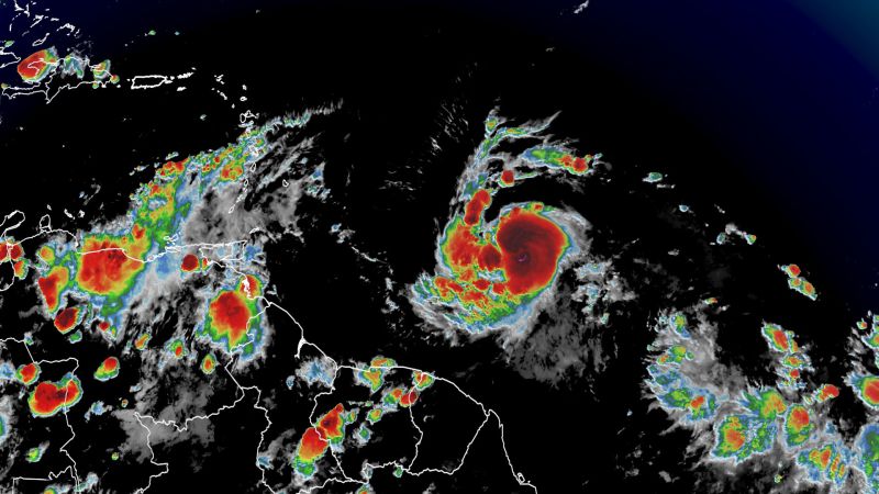
A satellite view of Beryl at 9 p.m. ET on Saturday.
Beryl’s rapid intensification is very unusual this early into hurricane season, according to Brennan. It’s rare for tropical systems to form in the central Atlantic east of the Lesser Antilles in June, particularly strong ones, with only a handful having done so, according to NOAA records.
If Beryl reaches Category 4 intensity before Thursday July 4, it would be the earliest recorded Category 4 hurricane in the Atlantic. The storm has already set the record for the easternmost hurricane to form in the Tropical Atlantic in June, beating a previous record set in 1933.
The central and eastern Atlantic traditionally become more active in August, in part because ocean temperatures have had time to warm and fuel developing systems.
This year, however, the Atlantic basin has seen above normal water temperatures and a lack of wind shear due to the transition from El Niño season to La Niña season, both of which are fuel for tropical development.
“Beryl has found an environment with very warm ocean waters for this time of year,” Brennan said.
Warmer waters in the Atlantic Basin have given tropical storms and hurricanes the opportunity to develop at a more rapid pace in an more eastward position, according to Brennan, allowing storms to become more powerful and therefore more destructive earlier on in hurricane season, which runs from June 1 until November 30.
“These are ocean water you’d normally see like in August or September, but now we’re seeing them in late June,” Brennan said. “It’s kind of opening up more of the deep tropical Atlantic for formation before we get to what would be the traditional peak of the hurricane season.”
Caribbean islands urge public to prepare ahead of hurricane
Authorities are urging residents to take precautionary measures, with several Caribbean nations under hurricane watches and warnings while Hurricane Beryl approaches and gains strength.
Officials in Barbados say the island is expected to feel the impact of the storm as early as late Sunday night. Its meteorological service is anticipating storm-force winds, 3 to 6 inches of rain, “hazardous” marine conditions and severe thunderstorms that may interrupt power utilities.
“All the regular preparations that we do for a hurricane is in full swing,” Minister of Home Affairs and Information Wilfred Abrahams said in a statement. “We have less than 48 hours until we expect to see the effects of this system impacting Barbados. Please use the time very wisely.”
Chandan Khanna/AFP/Getty Images
A boarded-up building is seen in Bridgetown, Barbados, on Saturday.
In Saint Vincent and the Grenadines, Prime Minister Ralph Gonsalves warns that the storm could hit the islands by Monday morning as a Category 2 hurricane. The meteorological service forecasts sustained winds of 74 to 110 mph or greater and rainfall of 4 to 6 inches.
“Kingstown is going to be flooded once this hurricane is on track,” Gonsalves said of the capital city. “Normally, two inches of rain – sustained rain – in a relatively short period of time will flood the city. Four inches will undoubtedly flood the city.”
In Saint Lucia, the government warns that the storm could bring “moderate to heavy showers, thunderstorms, and gusty winds” to the region. Prime Minister Philip J. Pierre is advising residents to make necessary preparations and review their family emergency plans.
In Grenada, the National Disaster Management Agency is also urging residents to prepare by having disaster supplies kits, trimming overhanging trees and branches, clearing drains and knowing where their emergency shelters are located.
Chandan Khanna/AFP/Getty Images
Cars line up at a gas station Saturday in Bridgetown, Barbados, as hurricane Beryl approaches.
Systems forming this early in the summer in this part of the Atlantic is a sign of the hyperactive hurricane season to come, according to research from Phil Klotzbach, a hurricane expert and research scientist at Colorado State University. Normally, ocean temperatures aren’t warm enough in June and July to help tropical systems thrive.
National Weather Service forecasters predict 17 to 25 named storms this season, with eight to 13 of those becoming hurricanes, including four to seven major hurricanes.
“That’s well above average,” Brennan noted.
The weather service says thats’s “due to a confluence of factors, including near-record warm ocean temperatures in the Atlantic Ocean, development of La Nina conditions in the Pacific, reduced Atlantic trade winds and less wind shear, all of which tend to favor tropical storm formation.”
Credit: Source link