







Corral Fire: Evacuation orders downgraded, LiveCopter 3 shows conditions in San Joaquin County
Two firefighters have been hurt while responding to the grass fire.
TONIGHT. THE PUSH TO CONTAIN A GRASS FIRE FIRE IN SAN JOAQUIN COUNTY. THE CORRAL FIRE STARTED AT 230 YESTERDAY. AND SINCE THEN, 14,000 ACRES HAVE BURNED. THE FIRE IS NOW 30% CONTAINED. LIVE COPTER THREE GIVING US A LOT OF INSIGHT. WE GOT THESE EXCLUSIVE IMAGES TODAY OVER THE FIRE EVACUATION WARNING ARE STILL IN EFFECT TONIGHT. THEY WERE JUST DOWNGRADED FROM ORDERS MOMENTS AGO. WE KNOW WESTBOUND 580 IS OPEN ON EASTBOUND 580. THE NUMBER ONE LANE IS OPEN AND THE NUMBER TWO LANE IS CLOSED FROM CORRAL HOLLOW ROAD TO SOUTH BIRD ROAD. THANK YOU SO MUCH FOR JOINING US AT 6:00. I’M BRITTANY HOPE AND I’M ANDREA FLORES. AT LEAST TWO FIREFIGHTERS WERE INJURED WHILE BATTLING THE FLAMES. AND SOME NEIGHBORHOODS ARE ALREADY SEEING MAJOR DAMAGE. SO HERE’S A LOOK AT THE PROGRESS OF THE FIRE OVER THE LAST 24 HOURS. ON YOUR LEFT IS A VIEW OF THE FIRE. THIS WAS AROUND NINE LAST NIGHT. YOU CAN SEE FLAMES BURNING ALONG THIS HILL NOW. SMOKE FILLED THE AIR AND WINDS WERE STRONG. IT’S A DIFFERENT STORY IN THAT AREA TODAY. YOU CAN STILL SEE SOME SMOKE THERE ON YOUR RIGHT, BUT YOU CAN SEE A LOT OF THE DAMAGE THAT THOSE FLAMES LEFT BEHIND, WHERE YOU CAN SEE THAT BLACK AREA ON THE GROUND THAT’S THE BURN SCAR WHERE THOSE FLAMES RIPPED THROUGH THAT AREA, SOME POSITIVE NEWS, ALL EVACUATION ORDERS WERE JUST DOWNGRADED TO WARNINGS. THAT’S WHY THE WHOLE AREA NOW IS YELLOW. BUT CAL FIRE SAYS THEY WANT EVERYONE TO BE ON ALERT AS THE WINDS STICK AROUND. TONIGHT, FIRE CREWS SAY ROAD CLOSURES ARE STILL IN PLACE ON SOUTH CORRAL HOLLOW ROAD AND ON CRISMON ROAD SOUTH OF I-5 FOR NON RESIDENTS. A TEMPORARY EVACUATION POINT IS OPEN AT THE LARGE CLOVER COMMUNITY CENTER IN TRACY. THAT’S AT 11 157 WEST LARCH ROAD. A LARGE ANIMAL SHELTER IS SET UP AT THE MANTECA UNIFIED SCHOOL DISTRICT BUILDING, AND THAT ADDRESS IS 2271 WEST LUIS AVENUE IN MANTECA. AS THE FIRE CONTINUES TO BURN, WE HAVE LIVE TEAM COVERAGE FOR YOU THIS EVENING. KCRA 3’S MICHELLE BANDUR IS IN A SAN JOAQUIN NEIGHBORHOOD THAT HAS BEEN HEAVILY IMPACTED BY THIS FIRE. KCRA 3’S LEE ANNE DENYER IS ALSO LIVE IN THAT AREA TONIGHT WITH MORE ON HOW THE FIRE IS IMPACTING PEOPLE WITHIN THAT AREA. BUT FIRST WE WANT TO START WITH METEOROLOGIST DIRK VERDOORN, WHO HAS BEEN TRACKING THE FIRE CONDITIONS AND THOSE ONGOING WINDS. DIRK WHAT’S HAPPENING NOW? YEAH, IT’S REALLY ALL ABOUT THE WINDS THAT WE SAW YESTERDAY. THOSE WINDS WERE SO STRONG. WE HAD WIND GUSTS THAT WERE 30 TO UP TO 45MPH AT TIMES IN THE AREA WHERE THE FIRE WAS BURNING, AND WE STILL HAVE WEST WINDS NOW. THEY DID SHIFT THIS MORNING AND INTO THE EARLY AFTERNOON, BUT NOW WE’RE SEEING THAT WEST WIND CONTINUE THROUGH THE AREA. BUT WHAT I WANTED TO SHOW YOU HERE, THIS IS THE BURN SCAR. SO YOU HAVE I-580 THAT RUNS THIS DIRECTION. YOU HAVE TRACY. OF COURSE YOU GOT THE AIRPORT NEAR HERE, BUT YOU CAN SEE HOW LARGE THIS IS. SO THE BURN SCAR COVERS QUITE A WIDE SWATH HERE OF THIS AREA. IT’S ABOUT EIGHT AND A HALF MILES LONG ALONG I-5 80. AND THEN IT GOES BACK ABOUT BETWEEN 4 TO 5 MILES DEEP UP INTO THE HILLS THERE. SO THE CORRAL FIRE, WE’RE LOOKING AT RIGHT NOW, WIND GUSTS BETWEEN 20 TO 30MPH. THOSE ARE THE REPORTS IN THAT AREA. WE EXPECT TO HAVE THE WINDS KIND OF STAY IN THAT RANGE, IF NOT GET A LITTLE BIT STRONGER AS WE GO THROUGH THE NIGHT. TONIGHT. HERE WE ARE AS WE MAKE OUR WAY INTO THE EVENING ABOUT 915. WE’RE LOOKING AT WIND GUSTS CLOSE TO 30MPH. WIND GUSTS ARE GOING TO STAY IN THAT RANGE AS WE HEAD PAST MIDNIGHT TONIGHT AND ON INTO MONDAY MORNING. THOSE WINDS EVENTUALLY ARE GOING TO TAPER OFF, BUT WE’RE STILL GOING TO DEAL WITH THOSE WEST WIND WINDS BEING PUSHED UP OVER THE COASTAL MOUNTAINS THROUGH MUCH OF TOMORROW BEFORE WE GET INTO TOMORROW NIGHT AND TUESDAY, AND THEN WE GET A NORTH WIND, WHICH AGAIN, NOT A GOOD WIN BECAUSE THAT DRIES OUT THINGS EVEN MORE. SO IT MAKES IT EVEN EASIER FOR FIRES TO START. SO THE FIRE DANGER IS GOING TO GO UP BY TUESDAY. WE’LL HAVE MORE ON THAT COMING UP. NOW BACK OVER TO YOU DIRK. THANK YOU SO MUCH. KCRA 3’S MICHELLE BANDUR IS LIVE IN THE HARDEST HIT NEIGHBORHOOD NEAR STEARMAN AND BERNARD ROADS, WHERE THE FIRE DESTROYED AT LEAST ONE HOME. MICHELLE, I KNOW YOU WERE JUST ABLE TO SPEAK WITH THE FAMILY IMPACTED BY THIS. WHAT DID THEY SAY? WELL, THEY ARE JUST DISTRAUGHT AND DEVASTATED OVER LOSING THEIR HOME. AND WE HAVE TO TELL YOU, THE CURTIS FAMILY DID GIVE US PERMISSION TO BE ON THEIR PROPERTY. AND YOU CAN JUST SEE THE DEVASTATION JUST SHOWING YOU WHAT THEY HAVE ON THEIR PROPERTY. THEY LIKE TO WORK ON OLD CARS AND YOU CAN SEE THERE’S A LOT OF CARS THERE THAT ARE BURNED OUT. YOU JUST SEE THE SHELLS THERE, A LOT OF TREES, OF COURSE, THAT ARE TAKEN DOWN. AND OF COURSE NONE OF THE STRUCTURES OR THE BUILDINGS ARE THERE. THE CURTIS SON TELLS ME THAT THE BACK BARN CAUGHT FIRE, AND THAT’S WHAT STARTED IT ON THEIR PROPERTY, AND IT JUST GOT OUT OF CONTROL. THERE. NOW, I ALSO WANT TO TELL YOU THAT CAL FIRE CREWS ARE ON SCENE HERE. STILL, THEY SAID THERE ARE SOME HOT SPOTS ON THE PROPERTY AND THEY’VE ALSO TAPED OFF, AS YOU CAN SEE RIGHT HERE, ALL OF THESE TREES HERE, THEY SAY IT’S DANGEROUS TO BE IN THAT AREA BECAUSE THEY’RE AFRAID THAT THE TREES MAY FALL. SO THEY’RE KEEPING AN EYE ON THAT. THEY ALSO TOLD US, JUST TO BE AWARE THAT, YOU KNOW, A HOT SPOT COULD COME UP HERE WITH THE WINDS THAT YOU CAN HEAR HERE. UM, AND THERE COULD BE WE HAVE TO MOVE AND GET OUT OF THE AREA. BUT, YOU KNOW, WHILE THE CURTIS IS HEATED, EVACUATION ORDERS, THEIR NEIGHBOR, WHO IS ACROSS THE STREET IN ONE HOUSE DOWN, DECIDED TO STAY AND DECIDED TO PROTECT HIS HOME. EVERYTHING AROUND US IS BURNING. ALL MY NEIGHBORS ARE BURNING. ALL THE NEIGHBORHOODS BURNING. EVERYTHING IS BURNING. MY PHONE IS GOING CRAZY. ALL DAY LONG. PEOPLE ARE WORRIED ABOUT YOU. OH YEAH, 100%. WE COULDN’T LEAVE. WE COULDN’T. NO ONE COULD COME IN. NO ONE COULD LEAVE. UH, IT’S JUST BEEN WILD. THE FIRES WERE JUST INSANE. 200 FOOT FLAMES. SMOKE EVERYWHERE. COULDN’T BREATHE. ONCE KERN GILL GOT HIS FAMILY TO SAFETY AND EVACUATED FROM THE NEIGHBORHOOD, HE STAYED TO PROTECT HIS HOME AS WELL AS HIS NEIGHBOR’S PROPERTY. YOU GOT YOUR SPRINKLERS? THE FLAMES JUMPED OVER THE EMBERS JUMPED OVER TO THE JUNIPER TREES AND LIT THOSE UP. AND THEN I HAD MY GARDEN HOSES GOING BECAUSE I DIDN’T WANT ALL THE EMBERS THAT WERE FLYING OVER TO MY PROPERTY. I WAS JUST PUTTING THEM OUT WITH THE GARDEN HOSE. 30 YEARS OF MEMORIES AND POSSESSIONS AND ALL GONE. THE ELDERLY COUPLE WHO LIVES HERE, 75 YEAR OLD CHRISTIE CURTIS AND HER HUSBAND, 84 YEAR OLD STEPHEN, SHOWED UP WITH THEIR KIDS TO SEE THE DAMAGE AND IF ANYTHING WAS LEFT OF THEIR HOME, THEY HAD ABOUT 10 OR 15 MINUTES FROM THE TIME THAT THE OFFICER KNOCKED ON THE DOOR TO TELL THEM TO GET OUT OF THE HOUSE AND THEY GRABBED THE DOGS. THE TURTLE, AND A LITTLE BIT OF CLOTHES AND LEFT. THEY DIDN’T EVEN REMEMBER TO TAKE MEDS OR ANYTHING LIKE THAT. SO THEIR HOUSES, YOU CAN SEE, IS COMPLETELY DESTROYED OUT HERE TRYING TO SAVE HOUSES, NEIGHBOR’S HOUSES BURNT TO THE GROUND. YEAH, IT WAS A VERY, VERY, UH, SAD THING TO SEE JUST PEOPLE’S HOUSES JUST BURNING UP YARDS BURNING UP. UNFORTUNATELY, OUR NEIGHBOR RIGHT THERE LOST THEIR WHOLE ENTIRE HOUSE. YEAH, I’M BACK OUT HERE, LIVE ON THE CURTIS PROPERTY. YOU KNOW, WE NOTICED THAT THEIR WIND CHIMES STILL HANGING IN THE TREE. THOSE DON’T LOOK TO BE BURNED AT ALL, BUT THE REST OF THEIR PROPERTY JUST LOST HERE. AND AGAIN, THE FAMILY JUST DISTRAUGHT. SO THE CURTIS’S THE SON TELLS ME THAT THEY WERE ABLE TO GET OUT WITH THEIR TWO DOGS AND THEIR TURTLE. AND WHEN THEY WERE HERE ON THE PROPERTY EARLIER TODAY, THEY FOUND A METAL STATUE OF A TURTLE, ONE OF THEIR FAVORITE, ONE OF HIS MOTHER’S FAVORITES. SO SHE WAS ABLE TO TAKE THAT WITH HER. ONLY ONE THING SHE WAS ABLE TO GET, BUT IT MEANS A LOT TO HER AND OF COURSE, HER CHILDREN. JUST SO GRATEFUL THAT THEIR PARENTS HEEDED THE EVACUATION ORDERS AND GOT OUT OF HERE. WHEN THEY DID, AND THAT NO ONE WAS HURT IN THIS CORRAL FIRE HERE IN THIS NEIGHBORHOOD REPORTING LIVE IN SAN JOAQUIN COUNTY, MICHELLE BANDUR OR KCRA THREE NEWS. IT IS SUCH A RELIEF TO HEAR THAT THEY’RE AT LEAST PHYSICALLY OKAY. MICHELLE, THANK YOU SO MUCH. KCRA 3’S. LEE ANNE DENYER IS ALSO IN THE FIRE AREA TONIGHT AND JOINS US LIVE FROM SOUTH CORRAL HOLLOW ROAD NEAR INTERSTATE 580. SO, LEANNE, WE CAN SEE SOME OF THAT DAMAGE BEHIND YOU. ANOTHER THING THAT WE’VE NOTICED IS THAT THOSE WINDS ARE STILL PRETTY SIGNIFICANT IN THAT AREA. WE CAN HEAR THEM IN YOUR LIVE SHOT. OH, DEFINITELY. UM, IT’S BEEN VERY GUSTY EVER SINCE WE WE GOT HERE. AND WE DO CONTINUE TO MAKE OUR WAY DOWN THE ROAD TO BRING YOU DIFFERENT, DIFFERENT VIEWPOINTS OF WHAT WE’RE SEEING OUT HERE. AND I DO WANT TO MENTION THAT JUST AROUND THE CORNER, JUST AROUND THE BEND THIS WAY, WE ACTUALLY CAME ACROSS A CAL FIRE CREW THAT WAS MOPPING UP, WAS WORKING ON THE AREA, BUT FROM WHERE WE WERE, WE WEREN’T ABLE TO GET A SIGNAL OUT. SO WE DID HAVE TO RUSH BACK OVER HERE TO BRING YOU THESE LIVE PICTURES OF WHAT WE’RE SEEING. BUT VERY MUCH STILL ACTIVE. THERE ARE CREWS FROM CAL FIRE. SOME MIGHT BE JUST DRIVING INTO OUR SHOT HERE IN JUST A MOMENT, AND SOME OTHER AGENCIES AS WELL. BUT REALLY JUST TAKE A LOOK AT THE DAMAGE THAT THAT THIS FIRE DID TO THE THE HILL SCAPE. HERE YOU CAN SEE JUST HOW CHARRED IT IS. AGAIN. CAL FIRE CREWS ARE STILL HERE, STILL WORKING ON GETTING THIS FIRE MOPPED UP AND UNDER CONTROL. WE’RE HOPING FOR AN UPDATE FROM CAL FIRE SHORTLY IN SAN JOAQUIN COUNTY, LEE ANNE DENYER KCRA THREE NEWS. LEANNE, THANK YOU SO MUCH FOR THE UPDATE AND IMAGES FROM YOU. THE VIEWERS AND OFFICIALS ARE HELPING US SEE THE IMPACTS FROM THE FIRE FIRSTHAND. MULTIPLE CREWS ARE WORKING TO CONTAIN THIS FIRE. CAL FIRE RELEASED THESE PHOTOS TO US FROM OVERHEAD AND YOU CAN SEE JUST HOW MANY FIELDS WERE BURNED. BUT LOOK AT HOW CLOSE THEY GOT TO HOMES THERE. THE FIRE LITERALLY GETTING FEET FROM HOMES IN THAT AREA. AND HERE’S ANOTHER VIEW AS WELL. FROM CAL FIRE. A BIG THANK YOU TO THEM FOR SENDING US THESE IMAGES. YOU CAN SEE I BELIEVE THAT MIGHT BE THE LAB IN THE AREA OR SOME SORT OF FACILITY. BUT AGAIN, THE FIRE RACING UP THOSE HILLS AND LUCKILY MOST OF THE PROPERTY WAS PROTECTED. AND TONIGHT CAL FIRE IS WORKING TO CONTAIN THE FLAMES. KCRA 3 SPOKE TO BATTALION CHIEF JOSH SILVEIRA ABOUT THEIR EFFORTS BRINGING THAT THAT FIRE PERIMETER, UM, TO AN AREA THAT’S ADVANTAGEOUS FOR US TO FIGHT IT RATHER THAN BE UP ON THE HILLS. IF WE CAN USE A PREEXISTING ROAD, UH, OR ROAD SYSTEM, UM, AND, AND BRING THE FIRE DOWN TO AN AREA WHERE IT’S SAFER FOR US TO ENGAGE, THAT’S ALWAYS GOING TO BE THE BEST BET. UM, IF CONDITIONS WARRANT THAT WE ALSO HAD FOLKS OUT, UH, IN OUR HEAVY EQUIPMENT, THE DOZERS PUSHING LINE, UH, DIRECT IN AREAS WHERE WE JUST DIDN’T HAVE PREEXISTING ROADS TO BRING THAT FIRE PERIMETER TO. AND, OF COURSE, IT’S BEEN JUST OVER 24 HOURS. BUT OFFICIALS ARE ALREADY WORKING TO DETERMINE THE CAUSE OF THE FIRE. KCRA 3’S ERIN HEFT SPENT THE MORNING TRAVELING BEHIND THE FIRE LINE. SHE HAS AN UP CLOSE LOOK AT THE EFFORTS ON THE GROUND. SMOKE RISING FROM THE HILLS AND VALLEYS SOUTHWEST OF THE CITY OF TRACY. LINES OF WILDLAND FIRE TRUCKS, ONE BY ONE, WORKING THEIR WAY BACK ON THE ROADS THAT WIND THEIR WAY THROUGH THE THOUSANDS OF ACRES WHICH ARE NOW BURNED. BLACK. WE HAVE CREWS FROM ALL OVER CALIFORNIA THAT ARE HERE ACTIVELY ENGAGED IN DIRECT SUPPRESSION EFFORTS. AT THIS POINT. WE MADE OUR WAY SUNDAY MORNING BACK BEHIND FIRE LINES, WITNESSING THE MANY HOMES STANDING UNSCATHED AMONG THE BURNED HILLS, THE SCORCHED EARTH STILL WARM BENEATH OUR FEET. WHAT YOU’RE LOOKING AT HERE IS CORRAL HOLLOW ROAD, THE NAMESAKE OF THE CORRAL FIRE, THE ORIGIN OF WHERE THE FIRE IGNITED, ACCORDING TO CAL FIRE. BACK WITHIN THESE HILLS, WE HAVE INVESTIGATORS ON SCENE. BOTH CAL FIRE INVESTIGATORS AND SHERIFF’S DEPARTMENT INVESTIGATORS ARE OUT COMBING THROUGH THE AREA OF ORIGIN AND TRY TO PINPOINT EXACTLY WHAT CAUSED THIS HEAT. STILL RISING FROM THE GROUND, LOGS OF WOOD HOLLOWED OUT AND BURNING FROM WITHIN FIREFIGHTERS. INTENTIONAL SETTING SOME OF THE GRASS ABLAZE, TRYING TO FURTHER MITIGATE ANY RISK. WE’RE BRINGING THE FIRE AND ALLOWING US TO TO ENGAGE IT ON OUR TERMS. AT THAT POINT, THERE’S A LOT OF THINGS THAT ARE TAKEN INTO ACCOUNT WHEN WE DO STUFF LIKE THAT. WE WANT TO MAKE SURE THAT WINDS ARE IN OUR FAVOR. UM, IT’S NOT JUST A TACTIC THAT WE USE WILLY NILLY. THE LARGEST FIRE CAL FIRE HAS UNDERTAKEN THIS YEAR, BRINGING ALL THE ELEMENTS TO CREATE QUITE THE CHALLENGE. A LOT OF THAT HAD TO DO WITH A BUNCH OF CONDITIONS LINING UP. WE HAD VERY, VERY TALL, DRY GRASS. IT WAS VERY, VERY DENSE. IT HAD TWO YEARS WORTH OF GROWTH IN IT, COUPLED WITH THE VERY, VERY STRONG WINDS AND IT LINED UP PERFECTLY WITH THE TOPOGRAPHY. THAT’S OUT HERE. SO, YOU KNOW, WE HAD THREE SUBSTANTIAL FACTORS ALL COME INTO ALIGNMENT AND REALLY ALLOW THIS FIRE TO TO GROW AT A VERY RAPID RATE IN TRACY ERIN HEFT KCRA THREE NEWS. CAL FIRE ESTIMATES IT WILL TAKE SEVERAL DAYS, IF NOT LONGER, FOR A FULL INVESTIGATION FOR THE VERY LATEST ON THIS FIRE, MAKE SURE TO DOWNLOAD THE KCRA THREE APP. YOU CAN GET UPDATES FOR ANY FIRES THAT BREAK OUT IN OUR REGION BY TURNING
Corral Fire: Evacuation orders downgraded, LiveCopter 3 shows conditions in San Joaquin County
Two firefighters have been hurt while responding to the grass fire.

Updated: 8:44 PM PDT Jun 2, 2024
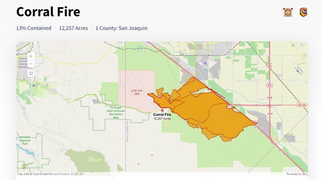
A dry grass fire that sparked south of Tracy in San Joaquin County on Saturday has burned more than 14,000 acres, prompted evacuations and injured at least two firefighters, Cal Fire said. At least one home was confirmed as destroyed. LiveCopter 3 footage showed the home was located at Bernard Road and Stearman Road.As of 11 a.m., the westbound side of Interstate 580 was back open. Caltrans said eastbound I-580 remained closed. Caltrans said Highway 132 has also reopened. (Video below: LiveCopter 3 has a view over the fire on Sunday around 11 a.m.)Follow our live nowcast coverage in the video player below tonight starting at 5 p.m. Growth of the Corral Fire and where it is burning According to Cal Fire, the fire has burned 12,500 acres and is 15% contained, as of Sunday morning at 8 a.m. That represented a growth of about 2,500 acres overnight.Containment is measured in percentages to describe a break or line where combustible material around the fire has been achieved, helping prevent the fire from spreading further.Cal Fire said about 400 personnel were attacking the fire and trying to box it in. Fire along the northside of I-580 has been contained and there did not appear to be damage to the roadway. It’s unclear whether other parts of I-580 were damaged. “Firefighters are struggling to get the upper hand of the fire,” said Josh Silveria with Cal Fire on Saturday night. He added that the winds were “extremely heavy.” Two firefighters suffered minor to moderate injuries and details on their conditions were unclear. The fire started around 2:30 p.m. near West Corral Hollow Road with an announcement that it had burned about 450 acres. The Lawrence Livermore National Laboratory said the fire started near its 300 Experimental Test Site but did not threaten the facility. The Corral Fire was unrelated to a series of recent controlled burns near the site, the laboratory said.Besides Cal Fire, the South San Joaquin Fire Authority, Tracy police and the San Joaquin County sheriff’s office were also assisting with the response. See here for a closer look at where the fire has burned. Windy conditions when the fire beganOur weather team said winds gusted more than 40 mph Saturday evening when the fire began. Meteorologist Heather Waldman said gusts have been a bit lower overnight and into Sunday morning, but geographically, this fire is located in an area that tends to be breezy.Expect winds from the west to increase again Sunday afternoon in the 30 mph range, she said. Smoke from the fire can be unhealthy for sensitive groups. Track air quality here. Footage of the Corral FireKCRA 3’s Erin Heft had a view of conditions on I-580 at Corral Hollow Road Sunday morning, while Kelly Curran was further south where the fire briefly jumped I-580 at Bird Road. KCRA 3’s Carolina Estrada and Orko Manna had a view of the fire late Saturday burning toward I-580. A viewer driving a Tesla Cybertruck sent a video of smoky conditions on I-580 at Highway 132 early Saturday evening.See more viewer videos and photos here. Corral Fire evacuation informationThe San Joaquin County Office of Emergency Services said an evacuation order was issued for residents west of the California Aqueduct, south of the Corral Hollow Creek, west to Alameda County and south to Stanislaus County. Cal Fire said the orders will be reduced to warnings by 6 p.m. During an evacuation order, there is an immediate threat to livelihood. It’s mandatory to evacuate in this case. There is a temporary evacuation point at the Larch Clover Community Center in Tracy. A shelter for large animals is being established at 2271 West Louise Avenue in Manteca. Power restored after outagesSeveral thousand Pacific Gas and Electric Co. customers lost power, though power has since been restored to nearly all of them. About 190 customers were still impacted early Sunday.| MORE | A 2024 guide for how to prepare for wildfires in CaliforniaHere are key websites that are important for all Californians during wildfire season.Cal Fire wildfire incidents: Cal Fire tracks its wildfire incidents here. You can sign up to receive text messages for Cal Fire updates on wildfires happening near your ZIP code here.Wildfires on federal land: Federal wildfire incidents are tracked here.Preparing for power outages: Ready.gov explains how to prepare for a power outage and what to do when returning from one here. Here is how to report track and report PG&E power outages.Keeping informed when you’ve lost power and cellphone service: How to find a National Weather Service radio station near you.Be prepared for road closures: Download Caltrans’ QuickMap app or check the latest QuickMap road conditions here.San Joaquin County emergency informationSan Joaquin County Office of Emergency ServicesSign up for the SJReady community notification systemSan Joaquin County neighborhood evacuation mapsFire departments in San Joaquin CountySee more coverage of top California stories here | Download our app.
A dry grass fire that sparked south of Tracy in San Joaquin County on Saturday has burned more than 14,000 acres, prompted evacuations and injured at least two firefighters, Cal Fire said. At least one home was confirmed as destroyed.
LiveCopter 3 footage showed the home was located at Bernard Road and Stearman Road.
As of 11 a.m., the westbound side of Interstate 580 was back open. Caltrans said eastbound I-580 remained closed. Caltrans said Highway 132 has also reopened.
(Video below: LiveCopter 3 has a view over the fire on Sunday around 11 a.m.)
Follow our live nowcast coverage in the video player below tonight starting at 5 p.m.
Growth of the Corral Fire and where it is burning
According to Cal Fire, the fire has burned 12,500 acres and is 15% contained, as of Sunday morning at 8 a.m. That represented a growth of about 2,500 acres overnight.
Containment is measured in percentages to describe a break or line where combustible material around the fire has been achieved, helping prevent the fire from spreading further.
Cal Fire said about 400 personnel were attacking the fire and trying to box it in. Fire along the northside of I-580 has been contained and there did not appear to be damage to the roadway. It’s unclear whether other parts of I-580 were damaged.
“Firefighters are struggling to get the upper hand of the fire,” said Josh Silveria with Cal Fire on Saturday night. He added that the winds were “extremely heavy.”
Two firefighters suffered minor to moderate injuries and details on their conditions were unclear.
This content is imported from Twitter.
You may be able to find the same content in another format, or you may be able to find more information, at their web site.
The fire started around 2:30 p.m. near West Corral Hollow Road with an announcement that it had burned about 450 acres.
The Lawrence Livermore National Laboratory said the fire started near its 300 Experimental Test Site but did not threaten the facility. The Corral Fire was unrelated to a series of recent controlled burns near the site, the laboratory said.
Besides Cal Fire, the South San Joaquin Fire Authority, Tracy police and the San Joaquin County sheriff’s office were also assisting with the response.
See here for a closer look at where the fire has burned.
Windy conditions when the fire began
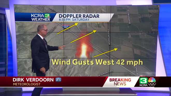
Our weather team said winds gusted more than 40 mph Saturday evening when the fire began.
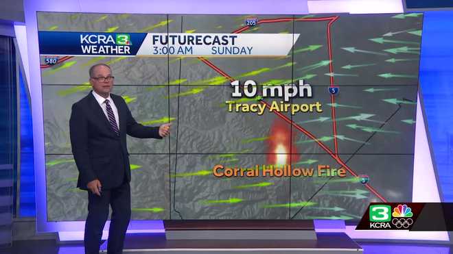
Meteorologist Heather Waldman said gusts have been a bit lower overnight and into Sunday morning, but geographically, this fire is located in an area that tends to be breezy.
Expect winds from the west to increase again Sunday afternoon in the 30 mph range, she said.
Smoke from the fire can be unhealthy for sensitive groups. Track air quality here.
Footage of the Corral Fire
KCRA 3’s Erin Heft had a view of conditions on I-580 at Corral Hollow Road Sunday morning, while Kelly Curran was further south where the fire briefly jumped I-580 at Bird Road.
KCRA 3’s Carolina Estrada and Orko Manna had a view of the fire late Saturday burning toward I-580.
A viewer driving a Tesla Cybertruck sent a video of smoky conditions on I-580 at Highway 132 early Saturday evening.
See more viewer videos and photos here.
Corral Fire evacuation information
The San Joaquin County Office of Emergency Services said an evacuation order was issued for residents west of the California Aqueduct, south of the Corral Hollow Creek, west to Alameda County and south to Stanislaus County.
Cal Fire said the orders will be reduced to warnings by 6 p.m.
During an evacuation order, there is an immediate threat to livelihood. It’s mandatory to evacuate in this case.
There is a temporary evacuation point at the Larch Clover Community Center in Tracy. A shelter for large animals is being established at 2271 West Louise Avenue in Manteca.
Power restored after outages
Several thousand Pacific Gas and Electric Co. customers lost power, though power has since been restored to nearly all of them. About 190 customers were still impacted early Sunday.
| MORE | A 2024 guide for how to prepare for wildfires in California
Here are key websites that are important for all Californians during wildfire season.
San Joaquin County emergency information
See more coverage of top California stories here | Download our app.
Credit: Source link