







A strong storm bringing wet snow, heavy rain and gusty winds will have a big impact in New Hampshire for Wednesday and Thursday.The National Weather Service has issued a winter storm watch for the entire state, except for coastal areas. >> National Weather Service alerts and bulletinsClouds will thicken Tuesday ahead of the storm as highs settle in the 40s with a light wind. Clouds continue to move in late Tuesday night as lows drop into the 30s.TIMINGExpect a long-duration period of wet snow and a wintry mix from late Wednesday morning through Thursday. >> Interactive RadarThe initial precipitation is expected to move in sometime Wednesday morning and will be around Wednesday afternoon and evening and into Thursday. Snow and wintry mix will be around for the evening commute. It will turn heavier later Wednesday night.The storm will make its closest pass Thursday afternoon and start to pull away Thursday night.The heaviest precipitation should wrap up Thursday night, with some lingering light rain and snow showers possible Friday.>> See the latest hour-by-hour storm timeline for snow, wintry mix and wind gusts:Travel conditions will likely be at their most difficult later Wednesday into Thursday.PROJECTED AMOUNTS & PRECIPITATION TYPESThe precipitation should start as a mix of snow and sleet with some pockets of heavy rain at the coastline and in southern communities before eventually changing to snow. Up north, it’ll be all snow as it arrives and continue that way for the duration of the event.The precipitation will likely convert to snow, even in southern areas, early Thursday.Expect 12-18 inches, or more, of snow across the eastern White Mountains, in the Mount Washington Valley and across parts of the North Country and Lakes Region. About 12-18 inches are also possible in the Dartmouth-Lake Sunapee Region. In parts of the northern North Country, the Upper Valley, the Monadnock Region and areas from Concord to Rochester, 6-12 inches are possible. About 3-6 inches could accumulate in far southwestern areas of the state and also from Manchester to Dover. Lesser amounts are possible at the coastline and in southern communities where the heavy rain and wintry mix hang on for the longest. In all, the storm will bring about 1-2 inches of liquid, and rivers and streams will respond to the precipitation. There will be minimal additional accumulation with the lighter showers on Friday.OTHER IMPACTSThe snow’s consistency will be heavy and wet, and that, combined with winds gusting over 35-40 mph, could lead to scattered power outages.The highest wind gusts will be at the coastline, but they will also be strong inland. Winds will be strongest from Wednesday afternoon through Thursday evening and should die down Friday.The storm is also causing concerns at the coastline. The high tide at Hampton Beach at 7:41 a.m. Thursday is the one to watch. Winds will be strong out of the east and northeast as the storm passes by offshore. Minor to moderate coastal flooding possible, along with minor beach erosion. Seas are forecast to be at 11.5 feet, which is well above normal. LOOKING AHEADAfter the light showers move out Friday, conditions will gradually improve over the weekend.So far, it looks quiet for Monday, when the total solar eclipse occurs in parts of northern New Hampshire. The rest of the state will see a partial eclipse. So, make sure to have a pair of eclipse glasses handy. Stay with the Storm Watch 9 team for updates.Be weather-aware! Download the WMUR app for Apple or Android devices and turn on push notifications. You can choose to receive weather alerts for your geolocation and/or up to three ZIP codes. In addition, you can receive word when precipitation is coming to your area.Get storm coverage through the free Very Local app on your smart TV.Follow the Storm Watch 9 team on social media:Mike Haddad: Facebook | XKevin Skarupa: Facebook | XHayley LaPoint: Facebook | XJacqueline Thomas: Facebook | XMatt Hoenig: Facebook | X
A strong storm bringing wet snow, heavy rain and gusty winds will have a big impact in New Hampshire for Wednesday and Thursday.
The National Weather Service has issued a winter storm watch for the entire state, except for coastal areas.
>> National Weather Service alerts and bulletins
Clouds will thicken Tuesday ahead of the storm as highs settle in the 40s with a light wind. Clouds continue to move in late Tuesday night as lows drop into the 30s.
TIMING
Expect a long-duration period of wet snow and a wintry mix from late Wednesday morning through Thursday.
>> Interactive Radar
The initial precipitation is expected to move in sometime Wednesday morning and will be around Wednesday afternoon and evening and into Thursday.
Snow and wintry mix will be around for the evening commute. It will turn heavier later Wednesday night.
The storm will make its closest pass Thursday afternoon and start to pull away Thursday night.
The heaviest precipitation should wrap up Thursday night, with some lingering light rain and snow showers possible Friday.
>> See the latest hour-by-hour storm timeline for snow, wintry mix and wind gusts:
Travel conditions will likely be at their most difficult later Wednesday into Thursday.
PROJECTED AMOUNTS & PRECIPITATION TYPES
The precipitation should start as a mix of snow and sleet with some pockets of heavy rain at the coastline and in southern communities before eventually changing to snow. Up north, it’ll be all snow as it arrives and continue that way for the duration of the event.
The precipitation will likely convert to snow, even in southern areas, early Thursday.
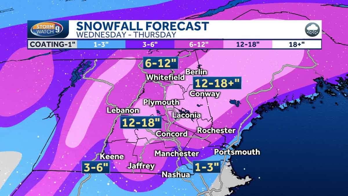
Expect 12-18 inches, or more, of snow across the eastern White Mountains, in the Mount Washington Valley and across parts of the North Country and Lakes Region. About 12-18 inches are also possible in the Dartmouth-Lake Sunapee Region. In parts of the northern North Country, the Upper Valley, the Monadnock Region and areas from Concord to Rochester, 6-12 inches are possible. About 3-6 inches could accumulate in far southwestern areas of the state and also from Manchester to Dover. Lesser amounts are possible at the coastline and in southern communities where the heavy rain and wintry mix hang on for the longest.
In all, the storm will bring about 1-2 inches of liquid, and rivers and streams will respond to the precipitation.
There will be minimal additional accumulation with the lighter showers on Friday.
OTHER IMPACTS
The snow’s consistency will be heavy and wet, and that, combined with winds gusting over 35-40 mph, could lead to scattered power outages.
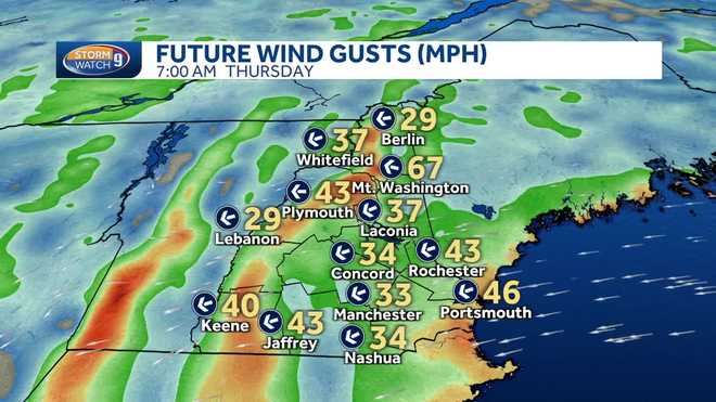
The highest wind gusts will be at the coastline, but they will also be strong inland. Winds will be strongest from Wednesday afternoon through Thursday evening and should die down Friday.
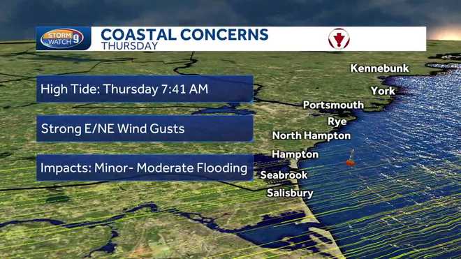
The storm is also causing concerns at the coastline. The high tide at Hampton Beach at 7:41 a.m. Thursday is the one to watch. Winds will be strong out of the east and northeast as the storm passes by offshore. Minor to moderate coastal flooding possible, along with minor beach erosion. Seas are forecast to be at 11.5 feet, which is well above normal.
LOOKING AHEAD
After the light showers move out Friday, conditions will gradually improve over the weekend.
So far, it looks quiet for Monday, when the total solar eclipse occurs in parts of northern New Hampshire. The rest of the state will see a partial eclipse. So, make sure to have a pair of eclipse glasses handy.
Stay with the Storm Watch 9 team for updates.
Be weather-aware! Download the WMUR app for Apple or Android devices and turn on push notifications. You can choose to receive weather alerts for your geolocation and/or up to three ZIP codes. In addition, you can receive word when precipitation is coming to your area.
Get storm coverage through the free Very Local app on your smart TV.
Follow the Storm Watch 9 team on social media:
Credit: Source link