






• bitcoinBitcoin(BTC)$79,896.000.06%
  • ethereumEthereum(ETH)$2,505.161.00%
  • tetherTether(USDT)$1.00-0.01%
  • binancecoinBNB(BNB)$752.73-2.34%
  • rippleXRP(XRP)$1.430.33%
  • usd-coinUSDC(USDC)$1.000.00%
  • solanaSolana(SOL)$106.142.26%
  • tronTRON(TRX)$0.3359920.41%
  • Figure HelocFigure Heloc(FIGR_HELOC)$1.065.02%
  • zcashZcash(ZEC)$1,231.0621.55%
  • HyperliquidHyperliquid(HYPE)$87.872.31%
  • dogecoinDogecoin(DOGE)$0.090492-0.69%
  • RainRain(RAIN)$0.016751-1.62%
  • moneroMonero(XMR)$531.77-2.93%
  • USDSUSDS(USDS)$1.000.02%
  • chainlinkChainlink(LINK)$12.967.45%
  • whitebitWhiteBIT Coin(WBT)$73.690.25%
  • leo-tokenLEO Token(LEO)$9.331.17%
  • cardanoCardano(ADA)$0.2220320.91%
  • stellarStellar(XLM)$0.1861080.45%
  • bitcoin-cashBitcoin Cash(BCH)$259.500.67%
  • daiDai(DAI)$1.000.00%
  • uniswapUniswap(UNI)$7.14-0.30%
  • CantonCanton(CC)$0.1104051.16%
  • Ethena USDeEthena USDe(USDE)$1.00-0.02%
  • litecoinLitecoin(LTC)$54.811.31%
  • USD1USD1(USD1)$1.000.01%
  • the-open-networkGram (prev. Toncoin)(GRAM)$1.430.08%
  • hedera-hashgraphHedera(HBAR)$0.0817821.08%
  • avalanche-2Avalanche(AVAX)$7.863.25%
  • suiSui(SUI)$0.810.82%
  • Global DollarGlobal Dollar(USDG)$1.00-0.01%
  • shiba-inuShiba Inu(SHIB)$0.000005-0.39%
  • nearNEAR Protocol(NEAR)$2.4412.01%
  • paypal-usdPayPal USD(PYUSD)$1.000.00%
  • BlackRock USD Institutional Digital Liquidity FundBlackRock USD Institutional Digital Liquidity Fund(BUIDL)$1.000.00%
  • crypto-com-chainCronos(CRO)$0.0576711.94%
  • tether-goldTether Gold(XAUT)$4,414.17-0.29%
  • Circle USYCCircle USYC(USYC)$1.140.00%
  • BittensorBittensor(TAO)$268.0614.06%
  • MemeCoreMemeCore(M)$1.130.00%
  • Ripple USDRipple USD(RLUSD)$1.000.01%
  • okbOKB(OKB)$113.630.58%
  • Ondo US Dollar YieldOndo US Dollar Yield(USDY)$1.150.04%
  • AsterAster(ASTER)$0.78-0.20%
  • aaveAave(AAVE)$134.670.26%
  • mantleMantle(MNT)$0.602.60%
  • pax-goldPAX Gold(PAXG)$4,419.48-0.31%
  • OndoOndo(ONDO)$0.3851803.54%
  • World Liberty FinancialWorld Liberty Financial(WLFI)$0.056646-1.51%
TradePoint.io
  • Main
  • AI & Technology
  • Stock Charts
  • Market & News
  • Business
  • Finance Tips
  • Trade Tube
  • Blog
  • Shop
No Result
View All Result
TradePoint.io
No Result
View All Result

Hurricane Lee path: Storm set to impact coastal New England and Atlantic Canada

September 15, 2023
in Market & News
Reading Time: 4 mins read
A A
Hurricane Lee path: Storm set to impact coastal New England and Atlantic Canada
ShareShareShareShareShare


CNN
 — 

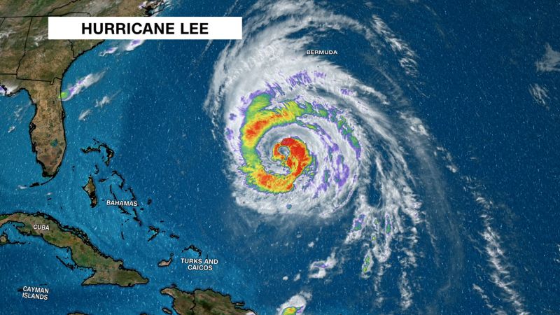
Hurricane Lee unleashed strong winds and tropical storm conditions on Bermuda ahead of a track that will bring heavy rain, wind and coastal flooding to coastal New England and Atlantic Canada on Friday and through the weekend.

YOU MAY ALSO LIKE

Divers clean famous underwater statue off Italian coast

Live Updates: Germany’s Far Right Has Big Lead in Key Election, Exit Polls Show – The New York Times

After days of uncertainty, there’s little time left for Lee’s track to change considerably, and confidence has grown now that the massive storm has completed its long-awaited northward turn and begun to pick up its pace.

Lee is expected to track far enough away from the East Coast to avoid delivering a substantial blow to a more widespread and inland area of New England, but will still affect the coast ahead of a weekend landfall somewhere between northeast Maine and the Canadian province of Nova Scotia.

Parts of the East Coast were already feeling the storm’s effects Thursday, including “dangerous surf and rip current conditions,” according to the National Hurricane Center.

Maine Gov. Janet Mills declared a state of emergency Thursday afternoon and requested federal assistance in preparation for Lee’s arrival.

Lee’s core was about 185 miles west of Bermuda as of Thursday night and was churning with maximum sustained winds of 85 mph – a Category 1 hurricane – according to the hurricane center. An island-wide tropical storm warning is in effect for Bermuda as Lee tracks west of the island.

Power outages mounted across Bermuda on Thursday afternoon as Lee’s winds battered the island, according to the island’s utility provider. Winds gusted up to 51 mph at Bermuda’s L.F. Wade International Airport.

View this interactive content on CNN.com

Hurricane and tropical storm watches have been issued for many of New England’s coastal residents in anticipation of the colossal storm’s impact on Friday and through the weekend.

A tropical storm warning issued along New England’s coast was extended northward to the US and Canada border, the hurricane center said in a 5 p.m. advisory. And a tropical storm warning in effect for the coast of Massachusetts was extended westward to Westport, according to the advisory.

Though the storm is expected to weaken as it approaches land, it will still have a massive radius of damaging winds that could pound coastal New England and Canada’s Atlantic provinces. As of Thursday night hurricane-force winds extended up to 105 miles from its center and tropical storm-force winds stretched for up to 345 miles, according to the hurricane center.

Hurricane-strength winds are possible from the northern coast of Maine into portions of the Canadian provinces of New Brunswick and Nova Scotia on Saturday. Tropical storm-force wind gusts are possible across a much larger area of New England and Atlantic Canada.

These strong winds will contribute to storm surge flooding up to 3 feet that could inundate parts of the southeast Massachusetts coast late Friday and Saturday.

Heavy rainfall could pose a flood threat to some already rain-drenched areas of the Northeast, where saturated ground may be particularly susceptible to flash flooding. Lee’s heaviest rain will fall over portions of Maine Saturday, but states like New Hampshire, Massachusetts and Rhode Island are not completely in the clear.

Lee could deliver 1 to 2 inches of rain from Rhode Island to northern Maine, while 2 to 4 inches of rain can fall across the Massachusetts Cape and much of Maine. Repeated downpours may bring up to 6 inches of rain to southeastern Maine.

The softened soil combined with stiff wind gusts will also increase the likelihood of downed trees, which in turn could knock out essential power lines and cause outages. Areas at and near the coast, which will feel the strongest of Lee’s winds, will be the most at risk of wind damage and power outages.

Credit: Source link

ShareTweetSendSharePin

Related Posts

Divers clean famous underwater statue off Italian coast
Market & News

Divers clean famous underwater statue off Italian coast

September 6, 2026
Live Updates: Germany’s Far Right Has Big Lead in Key Election, Exit Polls Show – The New York Times
Market & News

Live Updates: Germany’s Far Right Has Big Lead in Key Election, Exit Polls Show – The New York Times

September 6, 2026
OpenAI says autonomous agent hacked a startup
Market & News

OpenAI says autonomous agent hacked a startup

September 6, 2026
Modeling scout linked to Jeffrey Epstein found dead in Paris
Market & News

Modeling scout linked to Jeffrey Epstein found dead in Paris

September 6, 2026
Next Post
米グーグル幹部の社内交際問題

米グーグル幹部の社内交際問題

Leave a Reply Cancel reply

Your email address will not be published. Required fields are marked *

Search

No Result
View All Result
Crazy Market Spike!

Crazy Market Spike!

August 31, 2026
Wife of Chiefs offensive coordinator allegedly shot by son

Wife of Chiefs offensive coordinator allegedly shot by son

September 4, 2026
AI is redefining the workforce — and most planning models aren’t ready

AI is redefining the workforce — and most planning models aren’t ready

September 1, 2026

About

Learn more

Our Services

Legal

Privacy Policy

Terms of Use

Bloggers

Learn more

Article Links

Contact

Advertise

Ask us anything

©2020- TradePoint.io - All rights reserved!

Tradepoint.io, being just a publishing and technology platform, is not a registered broker-dealer or investment adviser. So we do not provide investment advice. Rather, brokerage services are provided to clients of Tradepoint.io by independent SEC-registered broker-dealers and members of FINRA/SIPC. Every form of investing carries some risk and past performance is not a guarantee of future results. “Tradepoint.io“, “Instant Investing” and “My Trading Tools” are registered trademarks of Apperbuild, LLC.

This website is operated by Apperbuild, LLC. We have no link to any brokerage firm and we do not provide investment advice. Every information and resource we provide is solely for the education of our readers. © 2020 Apperbuild, LLC. All rights reserved.

No Result
View All Result
  • Main
  • AI & Technology
  • Stock Charts
  • Market & News
  • Business
  • Finance Tips
  • Trade Tube
  • Blog
  • Shop

© 2023 - TradePoint.io - All Rights Reserved!