







CNN
—
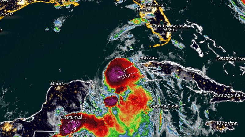
Idalia has strengthened into a hurricane with maximum sustained winds of 75 mph and stronger gusts and is expected to intensify considerably into a powerful Category 3 hurricane before making landfall in Florida on Wednesday, according to the National Hurricane Center.
The storm could deliver a devastating blow to portions of Florida’s Gulf Coast with life-threatening storm surge and damaging winds. It is expected to make landfall well north of Tampa, in Florida’s Big Bend region, but a small shift in the track could put the vulnerable population center more at risk.
Before it makes landfall, Idalia could produce a few tornadoes along the west central Florida coast Tuesday and northward into the Florida Big Bend by Tuesday night. Heavy rain could produce flash flooding across portions of the west coast of Florida, the Florida Panhandle, and southern Georgia Tuesday into Wednesday, spreading into portions of the eastern Carolinas Wednesday into Thursday.
The storm was churning roughly 370 miles southwest of Tampa early Tuesday, the hurricane center said in a 5 a.m. update.
“This is going to be a major hurricane,” Gov. Ron DeSantis said at a Monday news conference.
The storm is expected to dump 4 to 8 inches of rain from Tuesday into Thursday across parts of the west coast of Florida, the Florida Panhandle, southeast Georgia and the eastern Carolinas – where streets could flood.
As the storm makes its way to Florida, preparations could be seen across the state. Here’s the latest:
- Airports close: Tampa International Airport will suspend all commercial operations beginning Tuesday and stay closed until it can assess any damages later in the week, airport officials announced. The St. Pete-Clearwater International Airport Terminal building will close Tuesday afternoon.
- Evacuations in at least 10 counties: Hillsborough, Franklin, Taylor, Levy, Citrus, Manatee, Pasco, Hernando, Pinellas and Sarasota counties have all called for residents to evacuate certain at-risk areas.
- Schools close: 32 County School Districts have issued closures, as did multiple colleges and universities, including Florida State University, the University of Florida and Florida A&M University.
- Emergencies declared: DeSantis expanded an emergency declaration to 46 of 67 Florida counties on Monday morning. Several local jurisdictions have also declared emergencies.
- The Florida National Guard activated: More than 5,000 National Guard members were activated to help respond to the storm.
- US Navy ships begin leaving: Navy ships have begun leaving Florida ahead of Tropical Storm Idalia’s landfall, the Navy said Monday.
- Power outages expected: DeSantis told residents to prepare to be without power. “If you are in the path of the storm, you should expect power outages so please prepare for that,” the governor told residents Sunday.
- Hospital system suspending services: Patients will be transferred from at least three hospitals: HCA Florida Pasadena Hospital, HCA Florida Trinity West Hospital and HCA Florida West Tampa Hospital.
“We want everyone to take this storm seriously,” Barbara Tripp, Tampa’s Fire Rescue Chief said during a news conference.
The Fire Chief also asked citizens to clear debris from property ahead of the storm’s arrival and look out for neighbors who may need help.
“Once the wind reaches a certain miles per hour, Tampa Fire Rescue will not be able to respond,” Tripp warned.
With the storm forecast to strengthen quickly as it tracks through the Gulf of Mexico, it’ll be tapping into some of the warmest waters on the planet ahead of making landfall in Florida.
If it does so, it would join a growing list of devastating storms like monster Hurricane Ian — which leveled coastal Florida and left more than 100 dead — to rapidly intensify before landfall in recent years.
Idalia posed a “notable risk” of this phenomenon, the National Hurricane Center warned Monday, as it travels through the Gulf of Mexico.
Water temperatures around southern Florida climbed to 100 degrees Fahrenheit in some areas this summer, and temperatures in the Gulf overall have been record-warm, with more than enough heat to support rapid strengthening.
Life-threatening storm surge up to 12 feet is possible in Florida’s Big Bend – a danger that will only be worsened by waves fueled by hurricane-force winds stronger than 100 mph.
Storm surge, which is when a storm blows the ocean onshore, is one of the deadliest aspects of a hurricane and the reason behind most storm evacuations.
Cedar Key could be cut off by the high storm surge, National Hurricane Center Deputy Director Jamie Rhome said.
“I’m especially concerned for them,” Rhome said during a briefing on Facebook Live. “If you’re watching from Cedar Key, it is imperative that you take this very seriously and if ordered to evacuate, heed those evacuations immediately. The entire island could be completely cut off with conditions like that.”
Rhome stressed that evacuation orders that have been issued along the coast are in place because of the projected storm surge.
Storm surge accounts for nearly half of all hurricane-related fatalities, according to the National Oceanic and Atmospheric Administration.
It’s not just the coastal areas that could flood.
Inland areas, where people may evacuate to, could see hazardous flooding and heavy rainfall from Idalia.
Andrew Kruczkiewicz, senior researcher at the Columbia University’s Climate School, warns that heavy rainfall-related hazards can also occur as far as 100 miles away from where the storm center tracks.
“This is something that we’re seeing more and more, and this is a climate change connection because we’re seeing wetter tropical cyclones and wetter hurricanes,” he told CNN. “So we need to pay more attention to the risks associated with intense precipitation, especially in areas that are distant from the coastline.”
Credit: Source link